For hiking enthusiasts seeking an unparalleled adventure, hiking the Routeburn Track New Zealand stands as a pinnacle experience. This world-renowned Great Walk traverses spectacular landscapes, linking Fiordland National Park and Mount Aspiring National Park in the South Island. It is a journey through ice-carved valleys, beneath majestic peaks, and alongside reflective tarns, offering a profound connection with the raw beauty of New Zealand’s wilderness.
Planning Your Routeburn Adventure
The Routeburn Track is a 32 to 33-kilometer (20-21 miles) one-way trail, typically completed over three days and two nights. However, it can be extended to four days or even undertaken as a challenging two-day trek for experienced hikers. The track is classified as an intermediate-level hike during the Great Walks season, requiring a moderate level of fitness and some experience in remote areas.
Best Time to Hike and Booking Essentials
The optimal period for hiking the Routeburn Track is during the Great Walks season, which runs from November 1 to April 30. During this time, facilities are fully operational, bridges are in place, and Department of Conservation (DOC) rangers are present on the trail. Outside of this season, conditions can be challenging with snow, ice, and reduced facilities, making it suitable only for fit, experienced, and well-equipped individuals with alpine and navigation skills.
Bookings for huts and campsites are mandatory during the Great Walks season and are highly competitive, often selling out within minutes of release. It is crucial to plan well in advance and be prepared to book online as soon as the booking window opens, typically in May for the following season.
Trailheads and Direction
The Routeburn Track can be walked in either direction. The two main trailheads are the Routeburn Shelter, approximately 25 kilometers from Glenorchy, and The Divide Shelter, about 85 kilometers from Te Anau. Due to the track being one-way, arranging transport at both ends is essential. Various shuttle services operate between Queenstown, Glenorchy, Te Anau, and The Divide.
What to Expect on the Trail: Hiking the Routeburn Track New Zealand
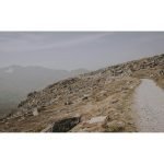
The Routeburn Track offers a diverse range of landscapes, from lush beech forests to exposed alpine passes. The total elevation gain is approximately 1,380 to 1,487 meters (4,510-4,879 feet).
You might also enjoy: Conquer the Ancient Heart: A Comprehensive Guide to Hiking Australia’s Larapinta Trail
- Routeburn Shelter to Routeburn Falls Hut: Starting from the Routeburn Shelter, the track gently winds alongside the crystal-clear Route Burn river, passing Bridal Veil Waterfall before climbing steadily through stunning beech forest to Routeburn Falls Hut. This section can take 2.5 to 4 hours. An alternative for the first night is Routeburn Flats Hut, located earlier along the track.
- Routeburn Falls Hut to Lake Mackenzie Hut: This is often considered the most spectacular section, climbing steadily through wetlands and tussock-covered flats. Hikers will sidle along bluffs above Lake Harris, reaching the highest point on the main track, Harris Saddle/Tarahaka Whakatipu, at 1,255 meters (4,117 feet). A day-use shelter is available at Harris Saddle. The track then descends along the exposed Hollyford Face, offering expansive views before reaching Lake Mackenzie Hut. This section typically takes 4.5 to 6 hours.
- Lake Mackenzie Hut to The Divide: From Lake Mackenzie, the track crosses a flat before climbing to the bushline. A gradual descent leads past the impressive Earland Falls (174 meters) and through beech forest to Lake Howden. From Lake Howden, the track continues downhill through silver beech forest to The Divide. This final section can take 4 to 5.5 hours.
Side Trips Worth Exploring
- Key Summit: A popular side trip near The Divide, the Key Summit track offers panoramic 360-degree views over Fiordland mountains and alpine lakes. This return walk takes approximately 1 to 2 hours and involves a steady climb to 918 meters (3,012 feet).
- Conical Hill: From Harris Saddle, a steep climb up Conical Hill (1,515 meters / 4,970 feet) offers superb views of the Hollyford Valley, Lake McKerrow, and even the Tasman Sea. This challenging return trip typically takes 1 to 2 hours from the Harris Saddle Shelter.
Essential Gear and Practical Preparation
Proper preparation is key to a safe and enjoyable experience on the Routeburn Track. The weather in New Zealand’s alpine regions can change rapidly, even during the Great Walks season.
- Clothing: Layered clothing, including thermal base layers, a warm fleece or down jacket, and waterproof and windproof outer layers, is essential. Bring a warm hat, gloves, and sun protection (hat, sunglasses, sunscreen).
- Footwear: Sturdy, broken-in hiking boots with good ankle support are crucial. Gaiters can be beneficial for muddy sections.
- Navigation: A physical map and compass, along with knowledge of how to use them, are recommended, even though the track is well-marked. A fully charged phone with offline maps can also be useful.
- Food and Water: Carry enough food for the entire trip, including emergency rations. Huts provide cold running water, but it should be boiled or treated before drinking.
- First Aid: A comprehensive first-aid kit, including blister treatment, pain relievers, and any personal medications, is vital.
- Other Essentials: Headlamp with spare batteries, toiletries, rubbish bags (pack out everything you pack in), and a portable power bank for electronics.
Navigation and Safety Considerations
While the Routeburn Track is well-maintained, safety should always be a priority. Always check the latest track conditions and weather forecasts from the Department of Conservation (DOC) before and during your hike.
- Weather: Be prepared for all four seasons in a single day. High winds, heavy rain, and even snow can occur unexpectedly, especially in exposed alpine sections.
- River Crossings: Heavy rainfall can cause rivers and streams to rise rapidly. Exercise extreme caution and be prepared to wait out high water if necessary.
- Emergency Procedures: Know how to signal for help and carry a personal locator beacon (PLB) for emergencies, especially if hiking outside the main season or in smaller groups. Cell phone reception is limited or non-existent in many areas.
- Track Conditions: Some sections are steep, rocky, and can be muddy or slippery. Pay attention to signage and any warnings from DOC rangers.
Connecting with Nature on the Routeburn Track
The Routeburn Track offers more than just a physical challenge; it provides a profound opportunity to connect with nature. As an experienced hiker, Summit Reid often reflects on the transformative power of trails like the Routeburn. The crisp alpine air, the symphony of native birds, and the sheer scale of the landscape combine to create a deeply immersive experience. Observing the delicate alpine flora, such as mountain buttercups and daisies, or spotting a native bird like the South Island robin, reminds one of the precious ecosystems being traversed.
The moments of quiet contemplation at Harris Saddle, gazing across the vast Hollyford Valley, or the serene beauty of Lake Mackenzie at dawn, are what truly define the journey. It is in these moments that the grandeur of the Southern Alps humbles and inspires, fostering a deep appreciation for New Zealand’s natural heritage. The track encourages a slower pace, allowing hikers to truly absorb their surroundings and find a sense of peace amidst the wild beauty.
Environmental Stewardship
Preserving the pristine environment of the Routeburn Track is paramount. Adhering to the Leave No Trace principles is essential:
- Plan Ahead and Prepare: Understand the regulations and potential hazards.
- Travel and Camp on Durable Surfaces: Stick to marked trails and designated campsites.
- Dispose of Waste Properly: Pack out all rubbish, including food scraps. Use designated toilets.
- Leave What You Find: Do not disturb plants, rocks, or historical artifacts.
- Minimize Campfire Impacts: Fires are generally not permitted on the track; use hut cooking facilities or a portable stove.
- Respect Wildlife: Observe animals from a distance and never feed them.
- Be Considerate of Other Visitors: Share the trail and maintain a respectful quiet.
By following these guidelines and embracing the Tiaki Promise, hikers contribute to protecting New Zealand’s unique environment for future generations.
You might also enjoy: Hiking The Wave Arizona: A Journey to a Geologic Masterpiece
Conclusion
Hiking the Routeburn Track New Zealand is an adventure that promises breathtaking scenery, challenging terrain, and an unforgettable immersion in nature. From the ancient beech forests to the exposed alpine passes, every step reveals a new vista and a deeper connection to the wild heart of the South Island. With careful planning, appropriate gear, and a commitment to environmental stewardship, this iconic Great Walk will undoubtedly be a highlight of any hiker’s journey. Start planning your Routeburn adventure today and discover the magic for yourself!
Frequently Asked Questions
What is the best time of year for hiking the Routeburn Track?
The best time for hiking the Routeburn Track is during the Great Walks season, which runs from November 1 to April 30. During these warmer months, facilities are fully operational, and conditions are generally more favorable, although alpine weather can still be unpredictable.
How difficult is the Routeburn Track, and what fitness level is required?
The Routeburn Track is classified as an intermediate-level hike during the Great Walks season. It requires a moderate level of fitness and some experience with multi-day trekking in remote areas. Hikers should be able to comfortably walk for 5-7 hours a day with a pack, navigating significant ascents and descents.
Are bookings required for the Routeburn Track huts and campsites?
Yes, bookings are essential for all huts and campsites on the Routeburn Track during the Great Walks season. These spots are highly sought after and often sell out within minutes of release, so it is crucial to book well in advance through the Department of Conservation (DOC) website.
What are the main highlights or must-see spots on the Routeburn Track?
Key highlights include the panoramic views from Harris Saddle/Tarahaka Whakatipu, the highest point on the main track, and the serene beauty of Lake Mackenzie. The optional side trips to Key Summit and Conical Hill also offer spectacular vistas of the surrounding alpine landscapes and valleys.
Related Adventures
- Conquer the Ancient Heart: A Comprehensive Guide to Hiking Australia’s Larapinta Trail
- Hiking The Wave Arizona: A Journey to a Geologic Masterpiece
- Unveiling the Majesty: Your Ultimate Guide to Hiking Routes in the Swiss Alps
⚠️ Safety Notice: This content is for informational purposes only. Always consult local guides and operators, verify current conditions, and ensure appropriate skills and certifications before any outdoor activity. DiveBikeHike is not responsible for injuries or incidents.